Recent Jurisprudence Addressing Maritime Delimitation Beyond 200 Nautical Miles from the Coast

The past two-and-a-half years have witnessed considerable development in the international law of maritime boundary delimitation.[1] In particular, this brief period has seen the historic emergence of jurisprudence addressing delimitation of a state’s maritime entitlements located beyond 200 nautical miles (M) from the state’s coastal baselines. In a string of recent disputes involving maritime jurisdiction in the Bay of Bengal, the Caribbean Sea, and the Pacific Ocean, international courts and tribunals—including the International Court of Justice (ICJ), the International Tribunal for the Law of the Sea (ITLOS), and an arbitral tribunal constituted under Annex VII of the UN Convention on the Law of the Sea (UNCLOS)[2]—have begun to address the unique and critical issues arising in such delimitations.[3] This Insight briefly describes three of the theoretical and practical problems revealed by this emerging jurisprudence.[4]
Background
In accordance with UNCLOS and customary international law, states have generally exercised sovereign rights and jurisdiction over two types of maritime entitlements beyond the 12-M territorial sea.[5] First, a state may declare entitlement to an Exclusive Economic Zone (EEZ) up to 200 M from its coastal baselines.[6] Throughout its EEZ, a state may exercise sovereign rights to exploit all “living or non-living” natural resources of the “seabed and its subsoil” and “the waters superjacent to the seabed.”[7] The coastal state also exercises jurisdiction in the EEZ with regard to environmental protection[8] and must have due regard for the rights of other states including, among others, the freedoms of navigation and overflight.[9]
Second, a state may exercise jurisdiction over the living and non-living resources of the continental shelf’s seabed and subsoil, including hydrocarbon resources and sedentary living species.[10] Although a coastal state’s sovereign rights with respect to the continental shelf “exist ipso facto and ab initio” under customary international law,[11] Article 76(8) of UNCLOS requires coastal states to establish the outer limits of the continental shelf on the basis of recommendations from the Commission on the Limits of the Continental Shelf (CLCS) regarding the geomorphological, bathymetric, and distance criteria set forth under Article 76(4) and 76(5).[12] Where the shelf does extend beyond 200 M, the state exercises the same sovereign rights as within 200 M. But entitlement to the outer continental shelf entails no rights to and does not affect the legal status of the superjacent water column.[13]
Where two or more states’ maritime entitlements overlap, the claimant states may divide the overlapping area by agreement or by submitting to the jurisdiction of an international court or tribunal. In accordance with UNCLOS and customary international law, such boundaries are often delimited along an “equidistance” line, every point of which is equidistant from the nearest points on the claimant states’ coastal baselines.[14] Where coastal geography or other factors would render an equidistance boundary inequitable, however, the boundary may diverge from equidistance. For example, international courts and tribunals have concluded that factors such as disparities in coastal length, the concavity of one state’s coast, or the presence of islands may necessitate divergence from equidistance.[15]
In sum, the allocation of maritime space is governed by interrelated but, at times, disharmonious rules. The extent of the EEZ is based purely on distance, whereas the outer limit of the continental shelf may be based on a combination of distance, bathymetry, geomorphology, and the thickness of the seabed’s sedimentary layer. Delimitation, finally, is often based on distance (or, more precisely, equidistance), but may diverge from equidistance based on coastal geography. The tension between such rules is heightened in maritime spaces beyond 200 M, as revealed in the recent jurisprudence.
Demonstrating the Existence of an Outer Continental Shelf
A threshold question in delimitation of maritime space beyond 200 M from the coast is whether any claimant state is entitled to the outer continental shelf based on the natural prolongation of its land mass. Whether maritime space beyond 200 M can be delimited before the CLCS has issued final recommendations is controversial.[16] As demonstrated in a 2013 survey, states often have not waited for a CLCS recommendation before delimiting their entitlements to the continental shelf beyond 200 M by treaty.[17]
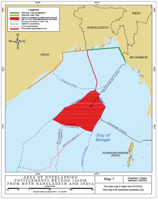
Similarly, the 2012 judgment by ITLOS in Bangladesh/Myanmar and the 2014 award by the Annex VII tribunal in Bangladesh v. India both explained that it was unnecessary to wait for CLCS recommendations before delimiting the continental shelf beyond 200 M in the Bay of Bengal.[18] Importantly, none of the three coastal states—India, Bangladesh, and Myanmar—disputed that an extended continental margin existed in the Bay of Bengal.[19] Indeed, all three states had already made full CLCS submissions and were awaiting recommendations.[20] Moreover, ITLOS and the Annex VII tribunal were in no doubt, given the sediment thickness in the Bay of Bengal, that all three states could satisfy the criteria of Article 76(4) and 76(5).
A more cautious approach was followed in the 2012 judgment in Nicaragua v. Colombia I by the ICJ, which declined to delimit any maritime spaces beyond 200 M from Nicaragua’s coast.[21] In that case, Nicaragua claimed entitlement to the outer continental shelf due to the presence of the “Nicaraguan Rise,” a shallow area of continental shelf extending from Nicaragua’s mainland and allegedly overlapping with maritime areas within 200 M of Colombia’s mainland.[22] On this basis, Nicaragua asked the ICJ to delimit a maritime boundary midway between the outer limit of Nicaragua’s continental shelf and the outer limit of Colombia’s EEZ. Such a delimitation between opposite coasts would likely have required the ICJ to determine not only whether Nicaragua was entitled to a continental shelf beyond 200 M, but also the location of Nicaragua’s outer limit.[23]
The ICJ declined, however, to delimit this alleged area of overlap.[24] As the ICJ explained, whereas both parties in Bangladesh/Myanmar had made full CLCS submissions, neither party in Nicaragua v. Colombia I had done so.[25] Colombia was not a party to UNCLOS, and Nicaragua had produced “only ‘Preliminary Information’ which, by its own admission, f[ell] short of meeting the requirements” of the CLCS process.[26] The ICJ therefore rejected Nicaragua’s request. As the ICJ explained, “the fact that Colombia is not a party thereto does not relieve Nicaragua of its obligations” under Article 76(8) of UNCLOS.[27] Accordingly, the ICJ performed no outer continental shelf delimitation “since Nicaragua, in the present proceedings, ha[d] not established . . . a continental margin that extends far enough to overlap” with the EEZ projected by Colombia’s mainland.[28]
Writing separately, Judge Donoghue, Judge ad hoc Mensah, and Judge ad hoc Cot each agreed with the ICJ’s conclusion, but disagreed with the majority’s explanation of its reasoning. According to these three judges, the critical flaw in Nicaragua’s claim was not procedural noncompliance with Article 76(8), but rather the failure to produce sufficient evidence regarding the existence and extent of the Nicaraguan Rise.[29] In these judges’ view, Nicaragua’s procedural failures under UNCLOS could not be invoked in a bilateral proceeding involving Colombia, which was not party to UNCLOS.[30]
Accordingly, Nicaragua v. Colombia I may be distinguished from the cases decided in the Bay of Bengal based on four factors: (1) Nicaragua had not complied with the procedural requirements of UNCLOS, (2) Nicaragua failed to prove its entitlement with sufficient evidence, (3) the opponent state, Colombia, had not conceded the existence of a Nicaraguan continental margin beyond 200 M, and (4) the ICJ would likely have been required to determine the precise location of Nicaragua’s outer limit to perform the requested delimitation. Future jurisprudence may provide guidance as to which of these factors are necessary or sufficient threshold conditions for delimitation of the outer continental shelf.
More answers will likely emerge from Nicaragua v. Colombia II.[31] After judgment was rendered in Nicaragua v. Colombia I, Nicaragua made a full CLCS submission in June 2013 regarding the continental margin in the Caribbean and filed a new application with the ICJ requesting delimitation in September 2013.[32] Although no final judgment will be forthcoming in Nicaragua v. Colombia II for several years, it is clear that a central issue will be the ICJ’s approach to evidence regarding the Nicaraguan Rise.
Division of Rights in the “Gray Area”
A second complexity arising in delimitations beyond 200 M is the division of rights within the so-called “gray area.” A gray area constitutes any maritime space situated beyond 200 M from State A’s coast, within 200 M of State B’s coast, and on State A’s side of the two states’ maritime boundary.[33] Such areas exist wherever a boundary deviates from equidistance beyond 200 M. Because relevant sections of the boundary in Bangladesh/Myanmar (which partially followed a 215º azimuth)[34] and the boundary in Bangladesh v. India (which partially followed a 177° 30′ azimuth)[35] deviate from equidistance beyond 200 M, both delimitations create gray areas.[36]
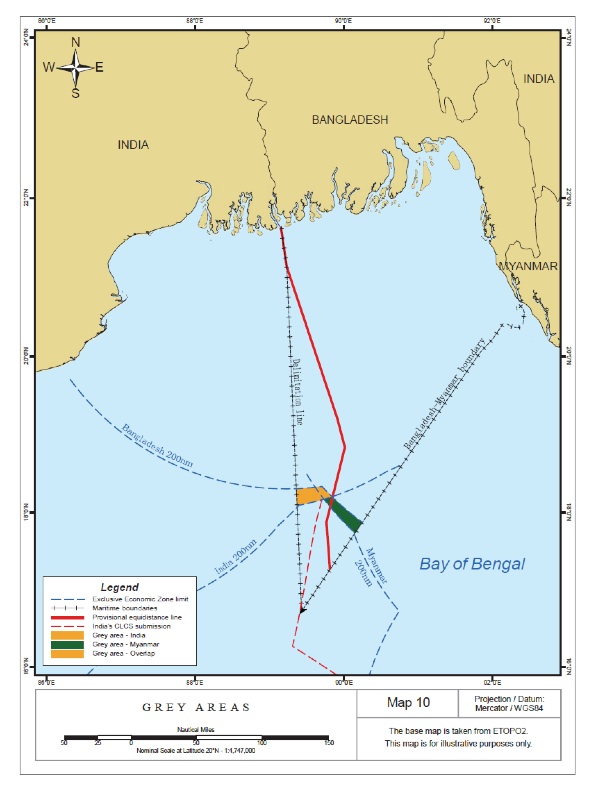
A difficult question arises as to the allocation of rights and responsibilities in the water column within any gray area. Because both gray areas in the Bay of Bengal are located more than 200 M from Bangladesh, Bangladesh’s EEZ does not encompass the water column in the gray areas.[37] However, because both gray areas fall on Bangladesh’s side of its maritime boundaries with India and Myanmar, Bangladesh is entitled to jurisdiction over the continental shelf in the gray areas. Neither India nor Myanmar can exploit the seabed and its subsoil within the gray areas, because their respective continental shelf boundaries with Bangladesh restrict them from doing so.
The result is that while the seafloor in the gray areas is unequivocally under Bangladesh’s jurisdiction, the water column in the same maritime spaces must either belong (1) to the opposing states as residual EEZ or (2) to the global common space known as the “high seas.” International lawyers have long recognized both possibilities in theory. If the former is correct, then a regime of bifurcated national jurisdiction emerges—one state exercises jurisdiction over the natural resources of the seafloor, while another exercises jurisdiction over the natural resources of the water column. If the second option is correct, then the water column in the gray area becomes an area of high seas in which all states share equal rights.[38]
The majorities in Bangladesh/Myanmar and Bangladesh v. India preferred bifurcation and allocated jurisdiction over the water column to Myanmar and India respectively.[39] Essentially the same reasoning was followed in both decisions. First, these decisions concluded that a tribunal’s “power to delimit the respective entitlements of the Parties exists only where those entitlements overlap,” such that a boundary delimiting rights to the continental shelf can have no effect on the superjacent water column.[40] The premise underlying this conclusion is that the two components of the EEZ—the water column and the seafloor—constitute fundamentally severable layers, such that one state’s jurisdiction over the water-column layer and another state’s jurisdiction over the seafloor layer cannot overlap in a manner susceptible to delimitation. Second, both majorities concluded that UNCLOS and customary international law have long recognized areas where states may have “shared rights” in certain maritime space.[41] For example, before the emergence of the EEZ in international law, most continental shelf entitlements were situated beneath the high seas.[42] Third, the two majorities were confident that the parties could resolve any practical awkwardness caused by bifurcation through negotiation.[43]
The decisions in Bangladesh/Myanmar and Bangladesh v. India were each accompanied by dissents voicing essentially similar concerns. First, the water column and the seafloor within 200 M may be conceptualized as “indispensable and inseparable parts” of a unitary EEZ, enabling delimitation where one state’s EEZ jurisdiction overlaps with another state’s continental shelf jurisdiction.[44] Second, the inherent practical difficulties of sharing a maritime space might weigh meaningfully against bifurcation, even if states can ultimately negotiate around such difficulties.[45] Indeed, the ICJ reasoned in Nicaragua v. Colombia I that “the public order of the oceans” tends to require “a simpler and more coherent division” of maritime space and maritime resources.[46]
Today, however, bifurcation enjoys the support of the only two decisions yet rendered by international courts and tribunals addressing gray areas. Bangladesh’s two gray areas actually overlap with one another—such that, in a small area of the Bay of Bengal, the seafloor falls under Bangladesh’s continental shelf jurisdiction while the water column remains subject to the overlapping EEZ entitlements of India and Myanmar.[47] Meanwhile, if the Nicaraguan Rise does allow Nicaragua to extend its continental shelf beyond 200 M and into the EEZ projected by Colombia’s islands or mainland, the ICJ may also soon be obliged to consider the status of another gray area.[48]
Redistribution of Sovereign Rights Where Entitlements Do Not Overlap
A third emerging question is whether and how states might validly redistribute their maritime jurisdiction in areas where their entitlements do not actually overlap. Indeed, although the majorities concluded in Bangladesh/Myanmar and Bangladesh v. India that the “power to delimit the respective entitlements of the Parties exists only where those entitlements overlap,”[49] states have occasionally concluded treaties purporting to reallocate and rearrange the placement of their maritime jurisdiction even where the states’ entitlements have not overlapped.
For example, in a 2010 treaty, Norway explicitly conferred on the Russian Federation “the sovereign rights and jurisdiction arising out of the jurisdiction in the exclusive economic zone that Norway would otherwise be entitled to exercise” in a section of the Barents Sea designated as “the Special Area.”[50] As Article 3 of the Barents Sea treaty explains, this Special Area is beyond 200 M from Russia’s coast, within 200 M of Norway’s coast, and on Russia’s side of the maritime boundary. Two more such “Special Areas” are identified in the Bering Sea under the 1990 maritime boundary treaty between the Soviet Union and the United States.[51] As did the Barents Sea treaty, the Bering Sea treaty also purported to transfer portions of each state’s 200-M EEZ to the other state even though the transferee state would ordinarily be considered too remote to extend its EEZ to encompass that maritime space.
At first glance, these innovative agreements are difficult to reconcile with the recent pronouncements by ITLOS and the Annex VII tribunal that the water column can only be delimited where two states’ entitlements to EEZ jurisdiction overlap. On the other hand, such state practice arguably suggests that states are able to redistribute their sovereign rights by arrangements that cannot be imposed upon them by international courts and tribunals, whose jurisdiction is based fundamentally on the parties’ consent.[52] The Barents Sea and Bering Sea treaties may also provide examples of what ITLOS called “appropriate cooperative arrangements,” by which states can circumvent the impracticalities of the bifurcated gray area.[53] In any event, no international court or tribunal has yet analyzed the effects of such innovative treaties or attempted to reconcile this state practice with recent jurisprudence.
An agreement of this general sort was alleged in the recent case of Peru v. Chile before the ICJ. Chile argued that the 1952 Santiago Declaration delimited a maritime boundary between Peru and Chile along a line of latitude running due westward.[54] This alleged boundary, in Chile’s view, prevented Peru from exercising any jurisdiction over a large, triangular maritime space (roughly the size of Albania)[55] located south of the boundary and within 200 M of Peru’s coast—although Chile itself possessed no entitlement overlapping with this “outer triangle.”[56] In its 2014 judgment, the ICJ rejected Chile’s argument[57] and concluded instead that Peru and Chile had tacitly agreed to a boundary extending only 80 M along the parallel of latitude.[58] The ICJ therefore was not obliged to address any issues relating to the outer triangle.[59]
Dissenting from the majority’s conclusion regarding the extent of the boundary, five of the individual judges concluded that Peru and Chile had delimited a boundary extending to Chile’s 200-M limit either by tacit agreement or by treaty.[60] Each of these five judges also agreed that the 1952 Santiago Declaration did not constitute a transfer or waiver of Peru’s rights in the outer triangle.[61] As the ICJ’s President, Judge Tomka, wrote in his individual declaration, “[t]here [wa]s no evidence that Peru ha[d] relinquished any entitlements under customary international law in areas . . . within 200 nautical miles of its coast.”[62] Neither President Tomka nor the other dissenters provided any further reasoning on the subject.
It therefore remains somewhat uncertain whether and how a state might validly, to use President Tomka’s expression, “relinquish” its sovereign rights and jurisdiction in an area where the parties’ maritime entitlements do not overlap. While the Barents Sea and Bering Sea treaties are both particularly explicit about transferring maritime jurisdiction over the “Special Areas” from one state to the other, it is also conceivable that states might create similar arrangements by tacit agreement. In this regard, the ICJ has observed that “[e]vidence of a tacit legal agreement must be compelling,” because “the establishment of a permanent maritime boundary is a matter of grave importance and agreement is not easily to be presumed.”[63]
Conclusion
As demonstrated by this recent jurisprudence, a variety of theoretical and practical problems arise from the dissonant rules governing maritime jurisdiction beyond 200 M. As the case law develops further, new answers will likely materialize to resolve these tensions.
About the Author: David P. Riesenberg is a law clerk to the Hon. Judge W. Eugene Davis of the United States Court of Appeals for the Fifth Circuit. He has previously worked for White & Case LLP and also assisted Myanmar’s legal team in Bangladesh/Myanmar. He is a member of ASIL’s International Environmental Law Interest Group and ASIL’s Law of the Sea Interest Group. Both ASIL interest groups sponsored this Insight. The author thanks Professor Coalter Lathrop and Professor Bjarni Már Magnússon for their invaluable comments and guidance. All errors are the author’s own.
[1] For additional analysis on recent maritime delimitation jurisprudence, see Naomi Burke, Annex VII Arbitral Tribunal Delimits Maritime Boundary Between Bangladesh and India in the Bay of Bengal, ASIL Insights (Sept. 22, 2014), http://asil.org/insights/volume/18/issue/20/annex-vii-arbitral-tribunal-delimits-maritime-boundary-between.
[2] United Nations Convention on the Law of the Sea, Dec. 10, 1982, 1833 U.N.T.S. 397 [hereinafter UNCLOS].
[3] See Bay of Bengal Maritime Boundary Arbitration (Bangl. v. India), Award (July 7, 2014), available at http://www.pca-cpa.org/showpage.asp?pag_id=1376; Maritime Dispute (Peru v. Chile), Judgment (Jan. 27, 2014), available at http://www.icj-cij.org/docket/files/137/17930.pdf; Territorial and Maritime Dispute (Nicar. v. Colom.), 2012 I.C.J. 624 (Nov. 19); Delimitation of the Maritime Boundary in the Bay of Bengal (Bangl./Myan.), Case No. 16, Judgment of Mar. 14, 2012, 12 ITLOS Rep. 4.
[4] See Bangl. v. India, supra note 3, ¶ 339 (“The ensuing—and still developing—international case law constitutes . . . an acquis judiciaire, a source of international law under article 38(1)(d) of the Statute of the International Court of Justice, and should be read into articles 74 and 83 of [UNCLOS].”).
[5] See Yoshifumi Tanaka, The International Law of the Sea 5–8 (2012). Although Article 33 of UNCLOS also provides for another type of zone under national jurisdiction, the contiguous zone, this maritime space in a sense “becomes part of the EEZ where it is established” for the purposes of exploiting and protecting natural resources. See id. at 6, 123. In any event, neither states nor international courts and tribunals have generally spoken of “delimiting” their contiguous zones. Another type of entitlement, the Fishery Zone, has been replaced to a considerable extent by the EEZ since the adoption of UNCLOS. See Robin Rolf Churchill & Alan Vaughan Lowe, The Law of the Sea 145 (2d ed. 1988). On at least one occasion, the ICJ has delimited a Fishery Zone using the same principles that are applicable in EEZ delimitation. See Maritime Delimitation in the Area Between Greenland and Jan Mayen (Den. v. Nor.), 1993 I.C.J. 38, 59 ¶ 47 (June 14).
[6] Tanaka, supra note 5, at 124–31; Churchill & Lowe, supra note 5, at 133–52.
[7] UNCLOS, supra note 2, art. 56.
[8] See id., arts. 56, 61.
[9] See id., art. 58.
[10] Tanaka, supra note 5, at 132–46; Churchill & Lowe, supra note 5, at 120–32.
[11] See North Sea Continental Shelf (F.R.G./Neth.; F.R.G./Den.), 1969 I.C.J. 3, 23 ¶ 19 (Feb. 20). States have frequently announced these rights explicitly in proclamations or declarations. See Proclamation No. 2667, 10 Fed. Reg. 12303 (Sept. 28, 1945); Peru v. Chile, supra note 3, ¶¶ 26, 113.
[12] UNCLOS, supra note 2, art. 76(8).
[13] See id., art. 78.
[14] See, e.g., id., art. 15 (defining an equidistance-based boundary for the purposes of delimiting the territorial sea).
[15] See, e.g., Bangl. v. India, supra note 3, ¶ 408; Nicar. v. Colom., supra note 3, ¶¶ 211, 215.
[16] See generally Bjarni Már Magnússon, Is There a Temporal Relationship Between the Delineation and the Delimitation of the Continental Shelf Beyond 200 Nautical Miles?, 28 Int’l J. Marine & Coastal L. 465 (2013); Bjørn Kunoy, Admissibility of a Plea to an International Adjudicative Forum to Delimit the Outer Continental Shelf Prior to the Adoption of Final Recommendations by the Commission on the Limits of the Continental Shelf, 25 Int’l J. Marine & Coastal L. 237 (2010); see also Bjørn Kunoy, The Delimitation of an Indicative Area of Overlapping Entitlement to the Outer Continental Shelf, 83 Brit. Y.B. Int’l L. 61, 77–78 (2013) (“In the absence of relevant recommendations of the Commission, it is not possible to determine the seaward extent of entitlement, unless a forum assumes those functions of the Commission, which is rather unlikely given . . . the complementary role of the Commission and relevant forums competent in outer continental shelf disputes.”).
[17] Bjarni Már Magnússon, Outer Continental Shelf Boundary Agreements, 62 Int’l & Comp. L.Q. 345 (2013).
[18] Bangl. v. India, supra note 3, ¶¶ 76–83; Bangl./Myan., supra note 3, ¶¶ 406–13.
[19] See Bangl. v. India, supra note 3, ¶ 78; Bangl./Myan., supra note 3, ¶¶ 440–41.
[20] Bangl. v. India, supra note 3, ¶¶ 81, 457; Bangl./Myan., supra note 3, ¶ 445.
[21] See Pieter Bekker, The World Court Awards Sovereignty Over Several Islands in the Caribbean Sea to Colombia and Fixes a Single Maritime Boundary between Colombia and Nicaragua, ASIL Insights (Jan. 15, 2013), http://www.asil.org/insights/volume/17/issue/3/world-court-awards-sovereignty-over-several-islands-caribbean-sea.
[22] Nicar. v. Colom., supra note 3, Verbatim Record, 12 ¶ 8 (April 24, 2012, 10 a.m.), http://www.icj-cij.org (Scientific and Technical Adviser for Nicaragua) (“This extensive shallow area is known as the Nicaraguan Rise. In Nicaragua’s case this physical continental shelf extends in a triangular shape about 180 miles towards Jamaica.”).
[23] But see Nicar. v. Colom., supra note 3, ¶ 128 (recounting Nicaragua’s argument that “the Court could make that delimitation by defining the boundary in words such as ‘the boundary is the median line between the outer edge of Nicaragua’s continental shelf fixed in accordance with UNCLOS Article 76 and the outer limit of Colombia’s 200-mile zone’”). While delimitation by such an open-ended formula would have been possible, it would have been difficult for an international court or tribunal to evaluate whether the relevant area delimited by the formula was allocated equitably.
[24] Id. ¶ 129.
[25] See id. ¶¶ 125–26.
[26] Id. ¶ 127.
[27] Id. ¶ 126.
[28] Id. ¶ 129.
[29] Id. ¶¶ 17–20 (declaration of Judge ad hoc Cot); id. ¶¶ 3–30 (separate opinion of Judge Donoghue); id. ¶¶ 2–12 (declaration of Judge ad hoc Mensah).
[30] Id. ¶¶ 19–20 (declaration of Judge ad hoc Cot) (“I remain sceptical of the Court’s finding that Nicaragua is bound, vis-à-vis Colombia, to respect its obligations under Article 76, paragraph 8, of the Convention, in order to delineate the outer limit of its continental shelf beyond 200 nautical miles . . . .”); id. ¶¶ 15, 25–28 (separate opinion of Judge Donoghue) (“The Court has not been presented with sufficient evidence in these proceedings to conclude that there is an area of continental shelf beyond 200 nautical miles of Nicaragua’s coasts . . . . [But i]t goes without saying that [States that are non-parties to UNCLOS] have no duty to make submissions to the Commission, so the Court’s observations regarding Nicaragua’s obligations to States parties to UNCLOS cannot be extended to them.”); id. ¶ 9 (declaration of Judge ad hoc Mensah) (“[T]he procedural requirements for obtaining a positive recommendation from the Commission under Article 76, paragraph 8, of UNCLOS . . . are only applicable where the States concerned are all parties to UNCLOS.”).
[31] See Question of the Delimitation of the Continental Shelf between Nicaragua and Colombia beyond 200 nautical miles from the Nicaraguan Coast (Nicar. v. Colom.), Application Instituting Proceedings (Sept. 16, 2013), http://www.icj-cij.org/docket/files/154/17532.pdf.
[32] See id. ¶¶ 5–10. Although Colombia withdrew from the ICJ’s jurisdiction under the Pact of Bogotá on November 27, 2012, Nicaragua argues that Colombia’s denunciation of the Pact of Bogotá had not yet taken effect at the time when Nicaragua’s second application was filed due to a one-year notice provision under Article LVI of the Pact. See id. ¶ 9.
[33] David Colson, The Delimitation of the Outer Continental Shelf Between Neighboring States, 97 Am. J. Int’l L. 91, 104–05 (2003); Alex G. Oude Elferink, Does Undisputed Title to a Maritime Zone Always Exclude Its Delimitation: The Grey Area Issue, 13 Int’l J. Marine & Coastal L. 143, 143–44 (1998).
[34] Bangl./Myan., supra note 3, ¶ 340.
[35] Bangl. v. India, supra note 3, ¶ 509.
[36] Bangl. v. India, supra note 3, ¶¶ 498–508; Bangl./Myan., supra note 3, ¶¶ 471–76.
[37] See Bangl. v. India, supra note 3, ¶¶ 498, 503; Bangl./Myan., supra note 3, ¶ 463.
[38] See UNCLOS, supra note 2, arts. 87, 89.
[39] Bangl. v. India, supra note 3, ¶ 505; Bangl./Myan., supra note 3, ¶ 474.
[40] Bangl. v. India, supra note 3, ¶ 503; Bangl./Myan., supra note 3, ¶ 471.
[41] Bangl. v. India, supra note 3, ¶ 507.
[42] Bangl./Myan., supra note 3, ¶ 475.
[43] Bangl. v. India, supra note 3, ¶ 508; Bangl./Myan., supra note 3, ¶ 476.
[44] Bangl. v. India, supra note 3, ¶ 31 (dissenting opinion of Dr. Rao) (“[S]overeign rights of a coastal State over the water column and the seabed and its subsoil are considered as two indispensable and inseparable parts of the coastal State’s rights in the EEZ . . . .”); see also Bangl./Myan., supra note 3, at 287 (dissenting opinion of Judge Lucky) (“It seems to me that continental shelf rights in the special circumstances of this case have priority over EEZ rights.”).
[45] Bangl. v. India, supra note 3, ¶¶ 35–37 (dissenting opinion of Dr. Rao) (“[A]s a matter of policy, international courts and tribunals should avoid delimiting boundaries in a way that leaves room for potential conflicts between the parties. . . . The grey area also has the potential to exacerbate bilateral relations and pose avoidable security problems.”); Bangl./Myan., supra note 3, at 285–86 (dissenting opinion of Judge Lucky) (“[A]ll of the foregoing may lead to further problems and issues and may be regarded as a failure on the part of the Tribunal to determine the issue.”).
[46] Nicar. v. Colom., supra note 3, ¶ 230; see also Continental Shelf (Tunis./Libya), 1982 I.C.J. 18, 232 ¶ 126 (Feb. 24) (dissenting opinion of Judge Oda) (“Is it congruous or conceivable that the same marine/submarine column should be placed under different national jurisdictions . . . and that the same area of the ocean be consequently policed by two different States? One is entitled to enquire whether [such a situation] is tolerable as a matter of international ordre public.”).
[47] Bangl. v. India, supra note 3, ¶ 506.
[48] See Nicar. v. Colom., supra note 3, Verbatim Record, 25–26 ¶¶ 49–51 (May 1, 2012, 3 p.m.), http://www.icj-cij.org (Counsel for Nicaragua) (“In other words, where State A’s natural prolongation continental shelf lies under State B’s EEZ, State A has the continental shelf ‘seabed’ rights, and State B has the EEZ rights in the water column . . . . And that, in our respectful submission, is . . . the correct approach in the present case.”).
[49] Bangl. v. India, supra note 3, ¶ 503; Bangl./Myan., supra note 3, ¶ 471.
[50] Treaty Concerning Maritime Delimitation and Cooperation in the Barents Sea and the Arctic Ocean, Nor.-Russ., art. 3, Sept. 15, 2010, 2791 U.N.T.S. ___, I-49095. See also Thilo Neumann, Norway and Russia Agree on Maritime Boundary in the Barents Sea and the Arctic Ocean, ASIL Insights (Nov. 10, 2010), http://www.asil.org/insights/volume/14/issue/34/norway-and-russia-agree-maritime-boundary-barents-sea-and-arctic-ocean.
[51] Agreement on the Maritime Boundary, U.S.-U.S.S.R., art. 3, June 1, 1990, 29 I.L.M. 941.
[52] See Monetary Gold Removed from Rome in 1943 (Italy v. Fr., U.K., U.S.), 1954 I.C.J. 19, 32 (June 15) (referring to the “well-established principle of international law embodied in the Court’s Statute, namely, that the Court can only exercise jurisdiction over a State with its consent”).
[53] See Bangl./Myan., supra note 3, ¶ 476.
[54] Peru v. Chile, supra note 3, ¶¶ 14, 22–23; Declaration on the Maritime Zone (Santiago Declaration), Aug. 18, 1952, 1006 U.N.T.S. 326. See also Uzma S. Burney, International Court of Justice Defines Maritime Boundary Between Peru and Chile, ASIL Insights (Feb. 10, 2014), http://www.asil.org/insights/volume/18/issue/3/international-court-justice-defines-maritime-boundary-between-peru-and-chile.
[55] See Peru v. Chile, supra note 3, Verbatim Record, 58 ¶ 35 (Dec. 4, 2012, 3 p.m.), http://www.icj-cij.org (Counsel for Peru) (referring to the disputed area as “une superficie équivalente à celle de l’Albanie”).
[56] See id., Verbatim Record, 37–38 ¶¶ 6.1–6.2 (Dec. 7, 2012, 3 p.m.), http://www.icj-cij.org (Counsel for Chile) (“Let me turn to Peru’s claim to the area Chile refers to as the ‘alta mar’ or what Peru refers to as the ‘outer triangle’ . . . . [T]he alta mar is an area of high seas. . . . Chile makes no jurisdictional claim to the alta mar under the Law of the Sea Convention.”).
[57] Peru v. Chile, supra note 3, ¶¶ 70, 91.
[58] Id. ¶¶ 104–51.
[59] Id. ¶ 189.
[60] See Peru v. Chile, supra note 3, ¶ 4 (declaration of President Tomka); id. ¶¶ 2, 9 (dissenting opinion of Judges Xue, Gaja, and Bhandari, and Judge ad hoc Orrego Vicuna).
[61] See id. ¶ 26 (declaration of President Tomka); id. ¶ 35 (dissenting opinion of Judges Xue, Gaja, and Bhandari, and Judge ad hoc Orrego Vicuna).
[62] See id. ¶ 26 (declaration of President Tomka).
[63] Territorial and Maritime Dispute (Nicar. v. Hond.), 2007 I.C.J. 659, 735 ¶ 253 (Oct. 8).