The World Court Awards Sovereignty Over Several Islands in the Caribbean Sea to Colombia and Fixes a Single Maritime Boundary between Colombia and Nicaragua

Introduction
In a judgment issued November 19, 2012, the International Court of Justice (âICJâ or âCourtâ) unanimously ruled that Colombia, not Nicaragua, has sovereignty over a number of contested islands and maritime features forming part of the San Andrés Archipelago in the western Caribbean. The Court also unanimously fixed the course of the single maritime boundary between the two countries largely based on a simplified weighted line favoring Nicaragua.[1] The case took a record eleven years to resolve.
Historical Background
Colombia and Nicaragua, which both gained independence from Spain and obtained sovereignty over their respective territories in the 19th century, concluded a treaty in 1928 (the â1928 Treatyâ) and an accompanying Protocol in 1930 purporting to put an end to their dispute concerning sovereignty over the San Andrés Archipelago and the Nicaraguan Mosquito Coast. However, following Nicaraguan protests concerning the signing by Colombia and the United States of the 1972 Vásquez-Saccio Treaty, whereby the U.S. renounced its claims to sovereignty over Quitasueño, Roncador, and Serrana, and Colombian protests triggered by Nicaraguaâs granting of oil exploration concessions in the Quitasueño area in 1969, Nicaragua denounced the 1928 Treaty as being null and void in 1980.
On December 6, 2001, Nicaragua instituted proceedings against Colombia before the ICJ in respect of a dispute comprising âa group of related legal issues subsistingâ between the two countries âconcerning title to territory and maritime delimitationâ in the western Caribbean. Colombia contested the ICJâs jurisdiction.
In its judgment of December 13, 2007, concerning Colombiaâs jurisdictional objections, the ICJ found that the 1928 Treaty was valid and definitively confirmed Colombiaâs sovereignty over the islands of San Andrés, Providencia, and Santa Catalina situated opposite Nicaraguaâs mainland coast. The Court unanimously ruled that it had jurisdiction, pursuant to Article XXXI of the 1948 American Treaty on Pacific Settlement, or âPact of Bogotá,â to adjudicate upon the dispute concerning sovereignty over the maritime features claimed by the parties other than those three islands, as well as the dispute concerning the maritime delimitation between them, thereby rejecting Colombiaâs argument that the 82nd meridian referred to in the 1930 Protocol constituted the boundary line of their respective maritime areas.[2]
Sovereignty Over Disputed Maritime Features in the Western Caribbean
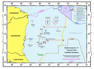
Under international law, a state with sovereignty over an island, whatever its size, is entitled to claim a 12-nautical-mile territorial sea and other maritime areas around it. Accordingly, in order to draw the maritime boundary between the two countries in the disputed area, the ICJ first had to determine which state had sovereignty over seven contested islands at Alburquerque Cays, Bajo Nuevo, East-Southeast Cays, Quitasueño, Roncador, Serrana, and Serranilla.[3]
As sources of their title to the disputed islands, the parties advanced arguments under the 1928 Treaty and the doctrine of uti possidetis, according to which boundaries inherited upon decolonization must be respected. Colombia also maintained that it had title based on effectivités, defined as âthe conduct of the administrative authorities as proof of the effective exercise of territorial jurisdiction in the region during the colonial [or post-colonial] period,â[4] and pointed to Nicaraguaâs alleged recognition of Colombiaâs title, positions taken by third states, and cartographic evidence.
The Court first observed that the partiesâ geographical and historical evidence relating to the 1928 Treaty, which confirmed Colombiaâs sovereignty over âthe islands of San Andrés, Providencia and Santa Catalina and over the other islands, islets, and reefs forming part of the San Andrés Archipelago,â was inconclusive as to the composition of that archipelago.
The ICJ also found that the available colonial-era evidence afforded inadequate assistance in determining sovereignty over the disputed maritime features on the basis of uti possidetis at the time of the partiesâ independence from Spain.
The Court next examined the conduct (effectivités) of the administrative authorities during the partiesâ post-colonial period and prior to the date when the dispute crystallized for proof of any effective exercise of territorial jurisdiction over the disputed maritime features. The ICJ considered, in particular: public administration and legislation; law enforcement measures; regulation of economic activities, including fishing; public works (e.g., maintenance of lighthouses); naval visits and search and rescue operations. The Court concluded that Colombia continuously and consistently had shown a strong overall pattern of conduct since 1969, when the parties exchanged diplomatic notes following Nicaraguaâs granting of oil exploration concessions in the disputed area, to demonstrate its intention to act as sovereign over the contested maritime features. Nicaragua could adduce no evidence of any effectivités.
Having found that, in addition to Colombiaâs effectivités, maps, Nicaraguaâs conduct, and the position taken by third states with regard to Colombian sovereignty over the disputed maritime features all afforded some support to Colombiaâs claim, the Court unanimously concluded that Colombia has sovereignty over those features.[5]
Course of the Maritime Boundary
As regards the Courtâs task of effecting a delimitation between the maritime entitlements of the Colombian islands and Nicaraguaâs exclusive economic zone (âEEZâ) and continental shelf within 200 nautical miles of the Nicaraguan coast,[6] Colombia requested the ICJ to draw a single maritime boundary, i.e., one uninterrupted boundary line delimiting the various zones of coincident jurisdiction appertaining to Nicaragua and Colombia, based on a median line between Nicaraguan fringing islands and the islands of the San Andrés Archipelago.[7] In order to avoid giving an allegedly disproportionate amount of the disputed waters to Colombia, Nicaragua sought the delimitation of a continental shelf boundary between the two countriesâ mainland coasts, with the islands of San Andrés, Providencia, and Santa Catalina being enclaved and accorded 12-nautical-mile zones and the other islands belonging to Colombia each receiving a three-nautical-mile enclave.
Given that Colombia is not a party to the United Nations Convention on the Law of the Sea (âUNCLOSâ), the applicable law in this case was customary international law, as reflected in UNCLOSâ Articles 74 (EEZ delimitation), 83 (continental shelf delimitation), and 121 (islands), and the decisions of international courts and tribunals.
The ICJ recalled that, in effecting a maritime delimitation involving overlapping zone entitlements, courts and tribunals normally employ a multi-stage methodology. After identifying the relevant coasts with a view to determining the partiesâ overlapping claims and the relevant area within which the delimitation is to be effected, a provisional delimitation line is established, usually an equidistance/median line, by reference to appropriate base points (Stage 1). The provisionally constructed line is then examined in the light of equitable factors, called ârelevant circumstances,â to determine whether it is necessary to adjust or shift that line in order to achieve an equitable result (Stage 2). The last stage in the delimitation involves the application of a final proportionality check to verify the equitableness of the tentative delimitation and to ensure that the ultimate result is not tainted by some form of gross disproportion (Stage 3).[8]
The parties advanced differing versions of the relevant coasts for purposes of drawing the provisional line. The ICJ concluded that the entire mainland coast of Nicaragua, with a length of some 531 kilometers, constituted the relevant Nicaraguan coast, while the relevant Colombian coast was confined to the coasts of the islands under Colombian sovereignty, measuring 65 kilometersâresulting in a ratio of approximately 1:8.2 in favor of Nicaragua. In determining the relevant coasts, the ICJ disregarded Bajo Nuevo, Quitasueño, and Serranilla. As regards the extent of the relevant area in which it was to effect the delimitation, the Court essentially adopted Nicaraguaâs version, which, at just over 200,000 square kilometers, is at least one-third larger than the area advocated by Colombia.[9]
Rejecting Nicaraguaâs enclave approach, the ICJ confirmed that under international law Colombia may claim a 12-nautical-mile breadth of territorial sea for each Colombian island within the relevant area. With regard to the overlap between Colombiaâs territorial sea entitlement derived from each island and Nicaraguaâs entitlement to a continental shelf and EEZ, the Court found that delimitation of this area, involving opposite coasts, could be satisfactorily accomplished by constructing a provisional median line, except that no base points should be placed on Quitasueño, Serrana, and Low Cay due to their small size.
The ICJ rejected Colombiaâs argument that no adjustment or shifting of the provisional median line was required in this case, finding instead that the substantial disparity in the lengths of the partiesâ relevant coasts, combined with the cut-off effect caused by a few islands denying Nicaragua access to the sea-bed and waters to their east (affecting three quarters of the area into which Nicaraguaâs coast projects), made strict application of the equidistance method inappropriate in the present case.
Consequently, in the western part of the relevant area, situated between the Nicaraguan mainland and the western coasts of Alburquerque Cays, San Andrés, Providencia, and Santa Catalina, and involving opposite coasts, the Court effected a significant eastward shifting of the provisional median line by applying a 3:1 weighting ratio between the base points on the Nicaraguan and Colombian islands used in the construction of the boundary line. Because the weighted line thus constructed produced a line with a curved shape and featuring many turning points, the ICJ adjusted the line further by reducing the number of turning points and connecting them by geodetic lines, resulting in a simplified weighted line favoring Nicaragua.
The Court further determined that, from the extreme northern and southern points of that line, the boundary follows the pertinent parallels of latitude until reaching the 200-nautical-mile limit from the baselines from which the territorial sea of Nicaragua is measured, with the first part of the southern line running along 12-nautical-mile envelopes of arcs around the islands situated in that area.
With regard to Quitasueño and Serrana islands, situated north of the northern limit of the line, the ICJ considered that the use of enclaves achieved the most equitable solution and fixed a boundary tracing 12-nautical-mile envelopes of arcs.
Finally, the ICJ determined that the line drawn by it did not entail such a disproportionality as to create an inequitable result.[10]
Click here for original
Concluding Observations
While the Courtâs judgment, rendered in the longest-running territorial and maritime delimitation case in ICJ history, confirms Colombiaâs sovereignty over disputed islands in the western Caribbean and does not attribute to Nicaragua the whole of the area it had claimed, in the aftermath of the ruling, Nicaragua expressed greater satisfaction over the boundary fixed by the ICJ than Colombia. This may be explained by the natural resources that are believed to be present in the maritime zones over which Nicaragua henceforth will be exercising rights. Notwithstanding the fact that ICJ judgments are binding and not subject to appeal, Colombia has announced that it will explore ways to overturn it.[11] On November 27, 2012, Colombia informed the Organization of American States of its decision to withdraw from the 1948 Pact of Bogota, thereby preventing future disputes involving Colombia from being brought before the ICJ on the basis of that treaty.
Maritime boundary cases are often triggered by competing claims to natural resources. The Courtâs ruling affirms the cautious treatment that international courts and tribunals have given to resource-related criteria when considering relevant circumstances, indicating that any issues of access to natural resources will be ignored unless they are âso exceptional as to warrant it treating them as a relevant consideration.â[12]
The Courtâs ruling is especially instructive regarding the determination of the status of islands, as opposed to low-tide elevations and other maritime features not capable of appropriation and of generating maritime entitlements.
It remains to be seen how this ruling will affect the authority of boundary lines, particularly pre-UNCLOS lines, established in existing instruments, especially in the context of the pending maritime delimitation case between Chile and Peru in which the ICJ will soon be issuing its decision. Will such lines, which often constitute simple parallel of latitude lines, as in the case of Chile-Peru, be recognized as de jure maritime boundaries, or are they merely territorial allocation lines open to re-drawing by international courts and tribunals having competent jurisdiction?
The ICJ ruling comes on the heels of the first maritime delimitation decision issued by the International Tribunal for the Law of the Sea (âITLOSâ), established under UNCLOS. On March 14, 2012, ITLOS fixed a single maritime boundary between Bangladesh and Myanmar, representing an adjusted equidistance line in the EEZs and continental shelves appertaining to Bangladesh and Myanmar, respectively.[13]The ITLOS case lasted only twenty-seven months.
Pieter H.F. Bekker, LL.M., Ph.D. (Intâl Law), an ASIL member, holds the Chair in International Law at the University of Dundeeâs Centre for Energy, Petroleum and Mineral Law and Policy (âCEPMLPâ) and is a Partner at Steptoe & Johnson LLP in Brussels (p.bekker@dundee.ac.uk). A former staff lawyer in the ICJ Registry and member of the New York Bar, he has appeared as counsel in several ICJ cases. Prof. Bekker has written or edited two books (Commentaries on World Court Decisions (1987-1996) (1998) and World Court Decisions at the Turn of the Millennium (1997-2001) (2002)) and numerous articles and notes on the ICJ. The views expressed herein are solely those of the author.
Endnotes: