Ghana and Côte d’Ivoire Receive a Strict-Equidistance Boundary
Introduction
In a unanimous ruling delivered on September 23, 2017, a Special Chamber of the International Tribunal for the Law of the Sea (ITLOS) fixed the course of the single maritime boundary between Ghana and Côte d'Ivoire both within and beyond 200 nautical miles (NM) from their coastlines.[1] Situated in an area in the Gulf of Guinea that is rich in hydrocarbons, the boundary represents a relatively rare "strict," or un-adjusted, equidistance line favoring Ghana.[2] The non-appealable ruling will require adjustments to practically all existing oil and gas blocks along the new line.
Background
In September 2014, following significant hydrocarbon discoveries, particularly in the Deepwater Tano Block containing the TEN (Tweneboa, Enyenra, Ntomme) fields, Ghana, relying on Annex VII of the United Nations Convention on the Law of the Sea (UNCLOS), commenced proceedings against Côte d'Ivoire before an ad hoc arbitral tribunal seeking delimitation of their common maritime boundary in the Atlantic Ocean. The two countries subsequently entered into a Special Agreement transferring the case to a Special Chamber of ITLOS in Hamburg.[3]
The parties not only advanced different methods to fix their maritime boundary, they also held differing views regarding the points along their coasts from which the boundary was to be measured (so-called base points) and the marine charts to be used in the delimitation. While the coasts of Côte d'Ivoire and Ghana are concave and convex, respectively, they otherwise are straight (i.e., not indented) and near-equal in overall length, as Figure 1 below shows.
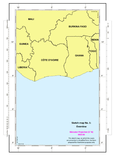
Fig. 1: Overview of parties' coastal geography (Sketch-map No. 1 from Judgment)
The Parties' Positions
Ghana's Position
Ghana submitted that both countries in issuing licenses for offshore mineral resource activities had mutually recognized and applied an equidistance-based boundary in the 12-NM territorial sea and their Exclusive Economic Zone (EEZ) and continental shelf within 200 NM from their coasts for more than a half century. Ghana also claimed that the countries' 2009 submissions to the Commission on the Limits of the Continental Shelf (CLCS)[4] pointed to their tacit agreement regarding the boundary beyond 200 NM.
In Ghana's view, the starting-point for the demarcation[5] of the allegedly agreed maritime boundary was the common land boundary terminus at border post 55 (BP55). The geographic coordinates of BP55 had been agreed upon by the two countries nine months before Ghana filed the case against Côte d'Ivoire.[6]
Ghana disagreed with Côte d'Ivoire that the disputed area features geographical circumstances capable of influencing the equidistance-based boundary advocated by it. Ghana submitted that, if the Special Chamber rejected its argument that there was an agreed boundary, the provisional equidistance line to be drawn by the judges should be based on a 10-kilometer segment on Ghana's coast and was to be adjusted to the west on account of the oil activities of both countries. In Ghana's view, those activities, taking the form of oil concession agreements and limits, legislative instruments, maps, and statements by public officials over a fifty-year period, reflect a modus vivendi regarding an equidistance boundary between the parties. The resulting boundary coincides with the western limit of Ghana's offshore oil blocks. Ghana also asked the Special Chamber to rule that the parties' boundary beyond 200 NM follows an extended equidistance boundary along the same azimuth[7] as the boundary within 200 NM, to the limit of national jurisdiction.
Côte d'Ivoire's Position
Côte d'Ivoire denied that there was an expressly agreed or "customary" boundary in place between the two countries. It rejected Ghana's reliance on oil activities in the disputed area and asked the judges to rule that the maritime boundary between Ghana and Côte d'Ivoire follows the 168.7˚ azimuth line, which both parties agreed starts at BP55 and extends to the outer limit of the continental shelf. Côte d'Ivoire relied on the angle bisector method to construct the boundary. Like equidistance, the bisector method is a geometry-based method for delimiting boundaries.[8]
Côte d'Ivoire submitted that application of the bisector method was appropriate in this case in light of the limited number of base points and their location on what it presented as an unstable coastline that is not representative of the overall coastal geography. It also pointed to the orientation of the countries' coastlines and the circumstance that the base points (typically, low-water line points) employed for the construction of the provisional equidistance line are all located on Jomoro on a small portion of the countries' coastlines. Jomoro is a narrow strip of Ghanaian land blocking the seaward projection of part of the Ivorian land mass.
Côte d'Ivoire also complained that the configuration of the narrow coastal segment employed for the construction of the equidistance line advocated by Ghana would cause a cut-off for its maritime area and that the resulting line was contrary to the objective of achieving an "equitable solution," the result dictated by UNCLOS for boundaries in maritime areas lying beyond the territorial sea.[9]
Côte d'Ivoire maintained that the same line could be construed based on either a bisector method or modified equidistance using the equidistance/relevant circumstances method favored by Ghana.
The Course of the Maritime Boundary
The Special Chamber noted that, over time, Côte d'Ivoire had invoked various methods for delimiting the maritime boundary, including the method favored by Ghana,[10] whereas Ghana advocated an equidistance line modified to account for the parties' oil activities. Finding no compelling evidence of a tacit agreement or estoppel regarding the parties' maritime boundary or of a modus vivendi between them affecting the boundary, the Special Chamber observed that both parties agreed, in principle, on the internationally established three-stage approach in applying the equidistance/relevant circumstances methodology invoked by both parties.[11] This approach and methodology can be summarized as follows:
|
Stage 1 |
After identifying the relevant coasts with a view to determining the parties' overlapping claims and the relevant area within which the delimitation is to be effected and in which the projections of the parties' coasts overlap, a provisional delimitation line is established, which in the majority of cases has been an equidistance line, by reference to appropriate base points |
|
Stage 2 |
The provisionally constructed line is examined in the light of equitable factors, called "relevant circumstances," so as to determine whether it is necessary to adjust or shift that line in order to achieve an "equitable solution" |
|
Stage 3 |
A final proportionality check is applied to verify the equitableness of the tentative delimitation and to ensure that the ultimate result is not tainted by some form of gross disproportion |
The Special Chamber concluded that only a portion of the mainland coast of Côte d'Ivoire, measuring 352 kilometers, constituted the relevant coast of which the seaward projection overlaps with Ghana's coastal projection.[12]
The Special Chamber was satisfied that delimitation of the disputed area could be achieved by constructing a provisional equidistance line.[13] Significantly, it identified a starting point and base points for the line that differ from those advanced by the parties. Given that the agreed border post 55 is located some 150 meters from the low-water line from which an equidistance line is to be measured, the Special Chamber, guided by the parties' coastline, fixed the starting point (BP55+) by extending the direction of the land border from border post 54 to BP55 until it reaches the low-water line.
The Special Chamber identified base points by re-digitizing the relevant coastline reflected on British Admiralty Chart 1383, which dates back to the nineteenth century. It then reduced the resulting high number of base points by using, for each party, only those points furthest from and nearest to the land boundary terminus and the points in the middle, yielding five base points for each country.[14] The resulting boundary, which starts from BP55+, features six turning points at which the direction of the line changes and which are connected by geodetic lines. From the southern-most turning point, the equidistance boundary continues as a geodetic line[15] until it reaches the outer limits of the continental shelf beyond 200 NM.[16] Details of the line are presented in Figure 4 below.
Having confirmed that it had the power to fix the course of the line delimiting the continental shelf beyond 200 NM, the Special Chamber emphasized that "there is in law only a single continental shelf."[17] While it did not fix a termination point, the Special Chamber found that this segment of the boundary runs in the same direction as the line within 200 NM.
Given that the boundary line thus fixed by the Special Chamber begins south and east of border post 55 (i.e., commences at a new starting point) and has its own turning points, plus its own azimuth, for the remainder of the single line, the final boundary line does not coincide with the equidistance line claimed by Ghana. The final boundary starts out east of Ghana's claimed line, crosses to the west (offshore) and then crosses again east nearing the 200-NM EEZ limit, before continuing to the extent of the continental shelf. Details of this can be seen in Figure 3 below.
The Special Chamber dismissed all of the parties' arguments that an adjustment or shifting of the provisional equidistance line was called for in the present case based on relevant circumstances such as concavity/convexity of the parties' coasts, the location of natural resources and the conduct of the parties.[18] It found that strict application of the equidistance method resulted in an equitable solution in this case. The Special Chamber also determined, in Stage 3, that the line constructed by it "does not lead to an inequitable result owing to a marked disproportion between the ratio of the respective coastal lengths and the ratio of the relevant maritime area allocated to each Party."[19]
The final delimitation line fixed by the Special Chamber is shown in Figure 2 below.
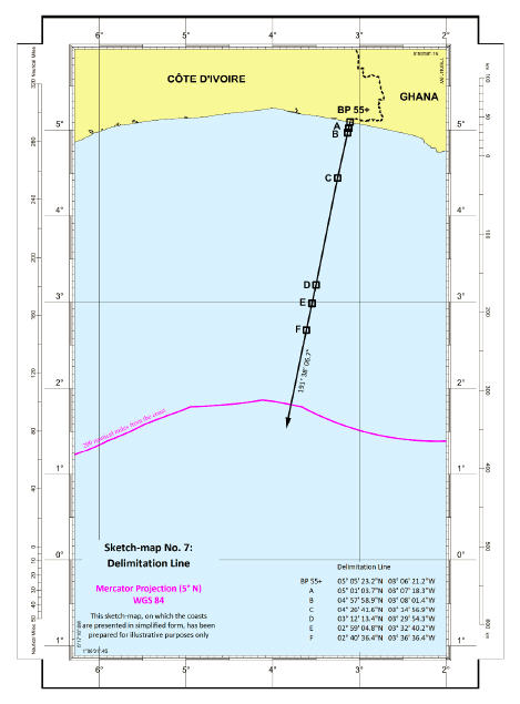
Fig. 2: Delimitation line (Sketch-map No. 7 from Judgment)
Concluding Observations
As this ruling underscores, maritime boundary delimitation involves a mixture of law and science, with geography prevailing over resource-related criteria such as the presence and location of hydrocarbons.[20] The Special Chamber's choice of nautical chart BA 1383, which reflects very old near-shore mapping that only shows the coastal low-water line in some places and otherwise falls short of the UN's scale guidelines,[21] apparently stems from the fact that both parties had relied on that chart until 2014 and had not jointly surveyed their coasts.[22] The boundary's starting-point (BP55+) resulting from the use of this chart sits 159.87 meters (geodetic) south and 18.43 meters east of the parties' agreed land terminus point (BP55), thereby favoring Côte d'Ivoire near-shore, as Figure 3 below shows. The fact that this new position, which originates from the use of the low-water line associated with the equidistance method applied by the Special Chamber, differs from the bilaterally agreed upon starting point means that the boundary line fixed by the Special Chamber nowhere coincides with the lines claimed by Ghana and Côte d'Ivoire.
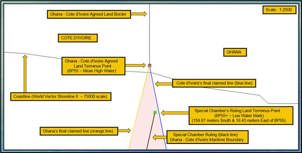
Fig. 3: Near-shore impact of Special Chamber's choice of boundary starting point
While the Special Chamber's chosen starting point of the maritime boundary favors Côte d'Ivoire near-shore along an initial segment measuring approximately 30 NM, Ghana received a boundary that is even more favorable than the boundary claimed by it along a segment of approximately 164 NM. The boundary fixed by the Special Chamber is actually seen to be sub-divided into three segments, with the final line initially lying east, then west and again east of Ghana's claimed equidistance line in the deepest waters as it approaches its approximate termination point at the outer portion of Ghana's extended continental shelf (ECS) claim, as recently accepted by the CLCS. See Figure 4 below for details.
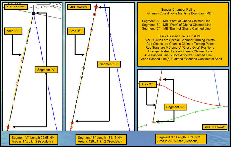
Fig. 4: Segment-by-segment difference between final boundary and parties' claimed lines
The table below shows the difference in distance between the parties' claimed lines and the Special Chamber's maritime boundary with reference to the key points constituting the boundary, using CARIS LOTS boundary software. The two far-right columns underscore the extent of Ghana's victory.
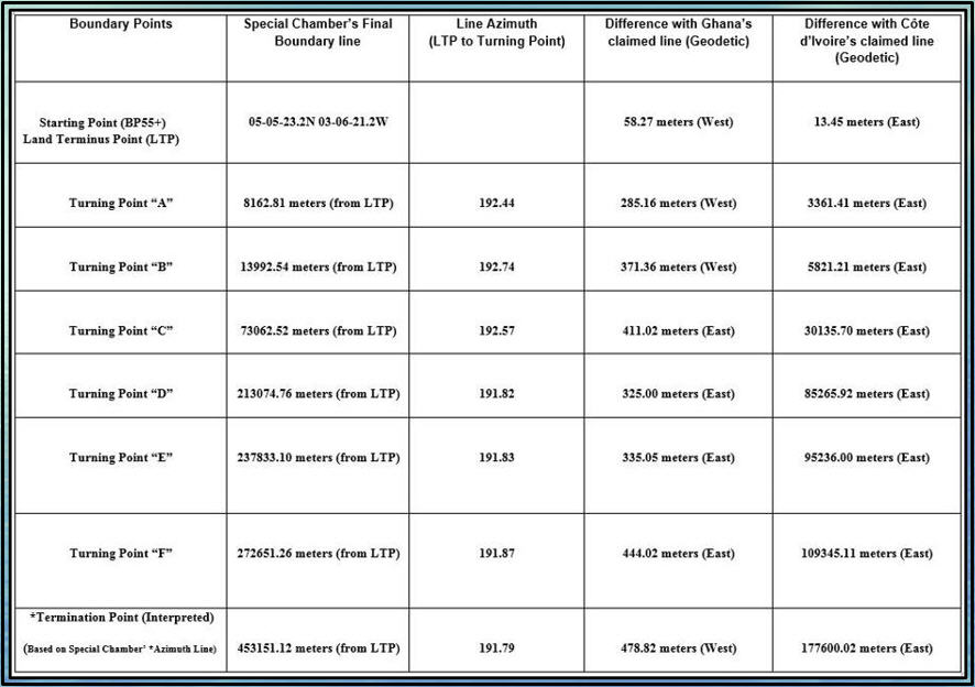
Table 1: Difference (geodetic) between final boundary and parties' claimed lines
The maritime boundary resulting from the Special Chamber's ruling will require adjustments to practically all existing blocks for mineral resource activities licensed by the parties along the adjudicated boundary. This is a direct result of the Special Chamber's line not coinciding at any point with the parties' claimed lines. Therefore, the ruling, while binding only for Ghana and Côte d'Ivoire, directly impacts oil companies holding offshore oil and gas blocks in the hitherto disputed area. Figure 5 below shows the issued and open blocks licensed by Côte d'Ivoire and Ghana, respectively, that are affected by the ruling, highlighting block gains and losses resulting from the ruling.
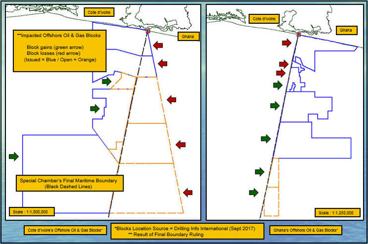
Fig. 5: Affected offshore oil & gas blocks on either side of the final boundary
Following this latest ruling, which was immediately welcomed in a joint statement by the agents representing Ghana and Côte d'Ivoire,[23] some 70 percent of Africa's lake and ocean boundaries remain to be delimited. This affects practically all of Africa's maritime waters, which hold offshore hydrocarbon reserves (EEZ and ECS waters) of approximately 95 billion Barrels Oil Equivalent (BBOE) (discovered) and, most importantly, yet-to-be-found reserves estimated at 70-80 BBOE, subject to basin limits.[24] Many of these areas, which are believed to harbor more than half of Africa's total reserves, are in near proximity to the present-day unresolved boundaries.
About the Authors:
Pieter Bekker, LL.M., Ph.D. (Int'l Law), an ASIL member, holds the Chair in International Law at the University of Dundee's Centre for Energy, Petroleum and Mineral Law and Policy (CEPMLP), where he is Founding Director of the Dundee Ocean and Lake Frontiers Institute and Neutrals (DOLFIN). He is also a Partner at CMS Cameron McKenna Nabarro Olswang LLP.
Robert van de Poll, B.Sc. (Earth Sciences), M.Sc.Eng. (Geodesy & Geomatics), is Global Manager Law of the Sea for Fugro Group. He is also the creator of CARIS LOTS, the leading Law of the Sea and maritime boundary software used by the United Nations and by international courts and tribunals, and serves as DOLFIN's Geology Director.
The views expressed herein are solely those of the authors. Errors are the authors' responsibility.
[1] Case Concerning Delimitation of the Maritime Boundary Between Ghana and Côte d'Ivoire in the Atlantic Ocean (Ghana/Côte d'Ivoire), Case No. 23, Judgment of 23 September 2017, ¶ 660, https://www.itlos.org/fileadmin/itlos/documents/cases/case_no.23_merits/C23_Judgment_23.09.2017_corr.pdf [hereinafter Judgment].
[2] An equidistance line is a line every point of which is equidistant from the nearest points on the baselines from which the breadth of the territorial sea and other maritime zones of each coastal state is measured.
[3] This transfer apparently was motivated by cost savings: In contrast to Annex VII proceedings, in which the parties must pay the fees and expenses of the arbitrators, the cost of an ITLOS Special Chamber is not borne by the parties. ITLOS Vice-President Boualem Bouguetaia of Algeria presided over the proceedings. The other members were former ITLOS President Thomas Mensah of Ghana (appointed by Ghana), International Court of Justice (ICJ) President Ronny Abraham of France (appointed by Côte d'Ivoire) and ITLOS Judges Rüdiger Wolfrum of Germany and Jin-Hyun Paik of the Republic of Korea.
[4] The CLCS is an UNCLOS body charged with making recommendations to coastal states on matters relating to the establishment of the outer limits of the continental shelf beyond 200 NM, without prejudice to the delimitation (i.e., fixing the course of the lateral limits) of maritime boundaries. See Convention on the Law of the Sea Art. 76 & Annex II, Dec. 10, 1982, 1833 U.N.T.S. 397. This was the first maritime boundary case in which one of the parties (Ghana) had already received and accepted recommendations on the outer limits of its continental shelf from the CLCS.
[5] According to the ICJ, "'demarcation' . . . presupposes the prior delimitation – in other words definition – of the frontier." Territorial Dispute (Libya/Chad), Judgment, 1994 I.C.J. Rep. 6, ¶ 56 (Feb. 3), available at http://www.icj-cij.org/files/case-related/83/083-19940203-JUD-01-00-EN.pdf.
[6] See Case Concerning Delimitation of the Maritime Boundary Between Ghana and Côte d'Ivoire in the Atlantic Ocean (Ghana/Côte d'Ivoire), Case No. 23, Memorial of Ghana, ¶ 2.2, https://www.itlos.org/fileadmin/itlos/documents/cases/case_no.23_merits/pleadings/Memorial_of_Ghana_Vol._I.pdf.
[7] As used in this analysis, "azimuth" means "the bearing of a geographical position, measured clockwise from north through 360 degrees." George K. Walker, Defining Terms in the 1982 Law of the Sea Convention III: Analysis of Selected IHO ECDIS Glossary and Other Terms, in Proceedings of the American Branch of the International Law Association 2003-2004, 214 (2004).
[8] As the ICJ has observed, "[t[he bisector method ... seeks to approximate the relevant coastal relationships, but does so on the basis of the macro-geography of a coastline as represented by a line drawn between two points on the coast." Territorial and Maritime Boundary between Nicaragua and Honduras in the Caribbean Sea (Nicaragua v. Honduras), 2007 I.C.J. 659, ¶ 289 (Oct. 8), available at http://www.icj-cij.org/files/case-related/120/120-20071008-JUD-01-00-EN.pdf.
[9] See UNCLOS, Arts. 74, 83 ("the delimitation . . . between States with opposite or adjacent coasts shall be effected by agreement on the basis of international law, . . . in order to achieve an equitable solution.").
[10] Judgment, supra note 1, ¶ 586.
[11] See id. ¶ 360.
[12] See id. ¶ 379. The relevant Ghanaian coast was found to measure some 139 kilometers, resulting in a ratio of approximately 1:2.53 in favor of Côte d'Ivoire. The ratio of the allocated areas is approximately 1:2.02 in favor of Côte d'Ivoire. See id. ¶¶ 536–37.
[13] The Special Chamber observed that the angle bisector method favored by Côte d'Ivoire has been applied by international courts and tribunals only occasionally when it was not feasible to construct an equidistance line due to the special geographical circumstances of the case. See id. ¶ 285.
[14] British Admiralty, Chart 1383, scale 1:350,000, published July 1, 2004 (Latest Edition dated June 15, 2017). This chart contains no low-water line information in general proximity to the land terminus point to be used by both coastal states in constructing their maritime boundary. The relevant coastline as depicted on this chart, which was last surveyed between 1837 and 1846, lacks any precision when compared to modern-day satellite imagery.
[15] The geodetic line starts at an azimuth of 191˚ 38' 06.7"
[16] Judgment, supra note 1, ¶¶ 399–401.
[17] Id. ¶ 490.
[18] Id. ¶¶ 402–80.
[19] Id. ¶ 533.
[20] According to the Special Chamber, "a de facto line or modus vivendi related to oil practice [of the disputing coastal states] cannot per se be a relevant circumstance" in maritime delimitation. Id. ¶ 477.
[21] See Baselines: An Examination of the Relevant Provisions of the United Nations Convention on the Law of the Sea, Ch. I.A., Art. 5, sub (8), ("It is recommended that in general the scale should be within the range 1:50,000 to 1:200,000"), Art. 5, sub (10) ("States . . . will usually select the low-water line shown on existing charts" (emphasis added)), UN Doc. E.88.V*.
[22] See Judgment, supra note 1, ¶ 342.
[23] See Ghana, Cote d'Ivoire Make Joint Pledge on ITLOS Ruling, Modern Ghana (Sept. 25, 2017), https://www.modernghana.com/print/805019/1/ghana-cote-divoire-make-joint-pledge-on-itlos-ruling.html.
[24] See Robert van de Poll & David Bishopp, "Unlocking Trapped Subsurface Resource Value in Disputed African Maritime Boundaries," Presentation Delivered at the 21st Africa Oil Week/Africa Upstream Conference, Cape Town (Nov. 2014), available at www.dundee.ac.uk/cepmlp/research/researchinstitute-dolfin/.